
If you were Peter or Shepherd Brooks and planning to build the first new speculative office building in 1879 Chicago, following the end of the Depression, where would you build it? While the 1871 fire had finally given Jenney an opportunity to design two downtown buildings, the Lakeside Building and the Portland Block, owned by the Brookses, the Bostonians did not return to him as the economy was improving, even though he was designing Leiter’s new building at that moment, to design their first post-recession speculative office building. This is especially noteworthy because the lot for their planned building was directly south of Jenney’s Portland Block that stood at the southeast corner of Dearborn and Washington. This fact leaves us with two questions?
1. Why did the Brooks continue to invest in Dearborn while the centroid of the reconstructed business district had shifted to the west and south with the temporary city hall and the relocation of the Custom House?
2. Why did they not continue with Jenney as their architect?

1.13. DEARBORN VS. LA SALLE: ACT TWO
It did not take long for office space construction to return to Chicago, once New York and the East Coast had started to rebound from the depression. The issue in Chicago of establishing the north/south (or railroad) office corridor to replace the original east/west (or river) office/financial corridor of Washington Street that had been stalled by the depression, would be resolved during the upcoming five-year period of economic expansion. In Volume One, I had discussed how Chicago’s urban structure, that had originally grown in an east-west axis paralleling the river (i.e., Water (W.Wacker)-warehouses, Lake-retail commercial, Randolph-hotel/office, Washington-churches) had rotated 90° to the south, in response to the Eastern railroads that came into town from the south, having to go around the bottom of Lake Michigan. (In truth, one might argue as some have tried, that because the lake stopped growth to the east, and the river, for all practical purposes, did likewise to the north and west, south was the only way for the city’s business district to grow. But this argument loses its credibility when one looks at all of the underbuilt sites in the business district that remained in 1880.)

The churches had moved to S. Wabash, the pre-fire wholesale district had moved to N. Wabash, only to move after the fire to Market (N. Wacker), Potter Palmer had made State Street the new commercial strip, while competing interests developed Dearborn versus La Salle as the office/financial district.

The Brookses’ original Portland Block of 1857, at the southeast corner of Dearborn and Washington had marked the rotation of the Washington Street office/financial district to Dearborn that was to be reinforced before the fire with the erection of the city’s first skyscraper, the Kendall Block at the southwest corner. Following the end of the war, H.H. Honoré’s (whose daughter Bertha had married Potter Palmer in 1870) had extended Dearborn south of the pre-fire Post Office and Custom House with the construction of three large office buildings between Monroe and Adams, seemingly in an attempt to parallel his new son-in-law’s development of State Street.

However, La Salle Street had the Courthouse/City Hall with the Chamber of Commerce at the southeast corner of Washington (mirroring the Portland Block’s location) at the north end, and it ran south to the one advantage that Dearborn did not possess, the station for the Michigan Southern/Rock Island Railroad.
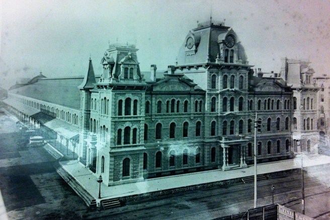
I documented William Ogden’s personal investment with both railroads in Volume One, so it was no coincidence that in 1871 he began construction of the Nixon Building at the northeast corner of La Salle and Monroe, exactly midway along La Salle between the station and City Hall (seemingly as a parry to Honoré’s Dearborn development).

The 1871 fire had forced City Hall to relocate to the surviving Water Reservoir at the southeast corner of La Salle and Adams, extending La Salle Street’s prime real estate another three and half block farther south, exactly as how the relocation of the Post Office/Customs House to Dearborn and Adams had provided a similar incentive along Dearborn. Quite frankly, a chess game could not have been played more masterfully, with the exception that Dearborn lacked a railroad station.

Boston’s Brooks brothers apparently had decided to cast their lot with Dearborn Street after the 1871 fire, when they chose to rebuild their Portland Block according to Jenney’s design, across Dearborn from where the shortened, post-fire version of the Kendall was being erected. In Volume One I had documented the suspicious nature of the move of the Post Office two blocks farther south on Dearborn, to the south to the block bounded by Dearborn, Adams, Clark and Jackson Streets, that provided a natural magnet to pull development south along Dearborn and noted that someone had made a bundle by selling this property to the Federal government. One must at least speculate, based on what we about to uncover, whether the Brookses had inside information or any involvement with this particular transaction.


(If you have any questions or suggestions, please feel free to eMail me at: thearchitectureprofessor@gmail.com)
